 Filter: Categories of Wisconsin Historical Images
Filter: FULL_DATE of 1799
Filter: Categories of Wisconsin Historical Images
Filter: FULL_DATE of 1799

| Date: | 1799 |
|---|---|
| Description: | Map of North America from the Great Lakes region to Baffins Bay. It shows settlements, Native American land, cities, trading houses and forts, mountains, a... |
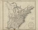
| Date: | 1799 |
|---|---|
| Description: | Map of the United States east of the Mississippi River. It shows borders, treaty lines, forts, cities, towns, Native American land, mountains, swamps, lake... |

| Date: | 1799 |
|---|---|
| Description: | Map of Rhode Island showing counties, townships, cities, roads, mountains, swamps, islands, reefs, lakes and rivers. Several of the bigger cities include s... |
If you didn't find the material you searched for, our Library Reference Staff can help.
Call our reference desk at 608-264-6535 or email us at: